Business
Topographic Survey- Study Of The Earth’s Surface

The topographic survey is the technique to evaluate the surfaces contour and elevation. It is the most convenient way of studying the surface of the earth and its various features. This technique is not only used in Geography but also in many fields of engineering. At many times topographical survey majorly deals with the astronomical objects such as other planets, the moon, and asteroids. In some cases, this particular term is also used in the medical field especially in neurology.

Thesurvey data in the UK is collected using a map where all the features of the land are shown.
Objective of Topographic Survey
Generally, topographic survey is used to evaluate both manmade and natural feature of a certain specified area of land. Local homeowners, builders, and business owners are in need of the survey of land due to expanding, constructing or renovating a property. It is a fact that topographic survey is the first step towards any construction jobs around the world.
Use of AutoCAD in Topographic Survey
An AutoCAD-based platform helps to quickly make the software into a topographic survey tool. The survey benefits the users with high efficiency and user-friendly topographical survey with the help of this drafting tool. The comprehensive tool is set for topographic survey calculation and drafting. AutoCAD skills help the drafting process to easy. AutoCAD 2D and 3D also helps in a low-cost survey preparation in the UK.
Features of Surveying with AutoCAD
It is said that the designing and shaping of the world around us can be done in a hassle-free way with this software. With the help of intelligent minds and this helping tool, one has the advantage of application of regional data standards are constructed. The topographic survey drawings are prepared in AutoCAD 2D and 3D whichever the clients prefers and then is printed on paper or film accordingly. Features of such a survey are:
•To reduce survey data and import Coordinate geometry Points
•Creating surface with break lines, with an update directly from the COGO points.
•Offset break line segmentation
•Simultaneous creation (2D and 3D) on user preferred layers which are ready for plotting
•Survey format which supports data transfer in PDF format
•Automates lot creation directly from the survey data
The integrating information one gets through such a survey is helpful for improving the quality, productivity and asset management for any government and non-government organisation.
The topographic survey benefits the entire community of geologic surveyors, oceanographic, civil and structural engineers, marine engineers, astrophysicists and many others. It is useful from local to international level. Itis the most convenient way to advance the work of these professionals. It provides most accurate data which helps in the understanding of a certain area. Government agencies also keep a record of these performed surveys.
The contours of a region many times help in preparing in advance and in avoiding or resisting natural disasters. The size, shape and elevation of any unknown object can be calculated if some relative data can be acquired regarding it.


Affordable and Efficient Mineral Water Supplier Services with Cold Water Dispensers
Staying hydrated is essential, whether at home or in the office. In Singapore, where the climate is warm and humid...


How Regular Car Service Appointments Improve Safety and Performance
Keeping your vehicle in top condition is essential not only for its reliability but also for your peace of mind...


Swimming Lessons Punggol: Private Swimming Lessons for Kids at Condo Pools
Life in Punggol has its own charm — a blend of modern living, family-friendly communities, and beautiful waterfront surroundings. Among...


Understanding Cooling and Protection Systems in Rectifier Transformers
Cooling and protection systems that are efficient are crucial for the rectifier transformers’ performance and reliability. The systems are responsible...


Understanding The Essential Role And Importance Of Car Crankshaft Repairs
When it comes to vehicle maintenance, most drivers focus on visible elements like oil changes, brake pads, or tyres. However,...
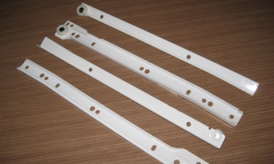

Understanding The Advantages Of Teflon Drawer Slides In Furniture Design
Have you ever struggled to pull open a stubborn drawer, or winced at the loud clank of your old metal...


Small to Medium Enterprise Success in Indian Castings
Small and Medium Enterprises (SMEs) in India are basically the foundation of the country’s manufacturing unit and hence innovation, jobs...


Stylish and Durable: Integrated Doors and Quartz Table Tops from Pryon International
When it comes to interior design, the choice of materials and finishes plays a crucial role in defining both the...


Boost Business Efficiency with Accounting & Secretarial Support
In today’s fast-paced business environment, small businesses in Singapore are expected to remain agile, compliant, and efficient to thrive. However,...


Discover Top-Quality Seafood from The Fish Farmer, Your Trusted Supplier
When it comes to enjoying the freshest and most flavorful seafood in Singapore, The Fish Farmer is the trusted name...


Transform Your Space: The Best Interior Design at Tradehub 21 by SG Home Furnishing
A well-designed interior space is more than just aesthetics—it’s about creating a home that feels uniquely yours, functions effortlessly, and...


The Power of Market Research in Shaping Marketing Strategies
Introduction Market research companies are essential players in shaping the success of any business. In today’s highly competitive and data-driven...


What to Consider Before Starting a Construction Project
If you are starting your own construction project, there are a few things that you will need to consider. It...


The Secret Details That Make Luxury Buildings Stand Out
When it comes to property, luxury isn’t all about the size of the building. Location doesn’t even qualify a property...
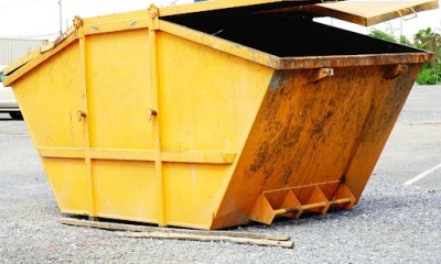

Essential Factors To Consider When Hiring Skip Services In Cranbourne
Have you ever started a home renovation only to realise your regular bins can’t handle the waste? Or worried about...
-

 Tech11 years ago
Creating An e-Commerce Website
-

 Tech11 years ago
Design Template Guidelines For Mobile Apps
-

 Business6 years ago
What Is AdsSupply? A Comprehensive Review
-

 Business10 years ago
The Key Types Of Brochure Printing Services
-

 Tech8 years ago
When To Send Your Bulk Messages?
-

 Tech5 years ago
5 Link Building Strategies You Can Apply For Local SEO
-

 Law5 years ago
How Can A Divorce Lawyer Help You Get Through Divorce?
-

 Home Improvement6 years ago
Hоw tо Kеер Antѕ Out оf Yоur Kitсhеn